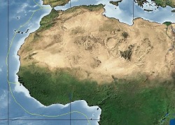
Standard SS7G1 The student will locate selected features of Africa
Atlas Mountain Range
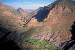
A group of mountains that separate the coastal regions from the great Sahara Desert.
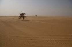
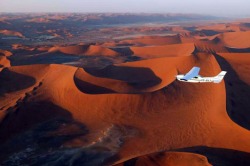
Sahara Desert
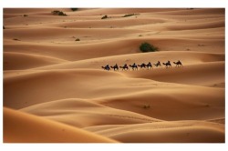
A barren region thatt runs across the entire width of northern Africa.
The largest desert in the world. It covers over 3.5 million square miles.
Few people live in this region; however traders travel across it using camels, jeeps, and trucks. Many consider the Sahara as one of the most difficult places to live on Earth.
Most people who live in the Sahara are nomads-they move from place to place, usually travel by camel, looking for water or food.
An oasis is a small place with water. Trees are able to grow and people can live with grazing animals and a few crops.
There are several parts of the Sahara that are virtually impossible to travel without camels.
Sahel
A dry, semi-arid region located south of the Sahara.
It forms a wide band stretching from the Atlantic Ocean to the Red Sea and covers about 1.8 million square miles.
A region between the desert to the north and the grasslands and rainforest to the south. It is relatively flat with few mountains and hills.
It is slowly turning into a desert (desertification) due to overgrazing of livestock and subsistent farmers cutting down trees for farmland.
Generations of people have tried to live here.
There is little rain in this region.
The removal of plants has caused the soil to become drier and to blow away.
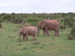
Savanna
A region where grass is able to grow naturally.
Usually does not have enough rainfall to sustain trees and forests.
A vast area of grassland and tropical habitats located in the middle of the continent close to the equator.
Many of the animals associated with Africa are found in this area-lions, elephants, buffaloes, hyenas, cheetahs, and many other species of animals.
Farming is good here when the rain comes. However, lack of rainfall can cause difficulties for farmers.
The African savanna is the largest in the world. It covers half of Africa.
The increasing population in Africa causes more grassland to be fenced in and plowed for crops.
Expanding farmland means less land for animals causing natural animal habitats to disappear.
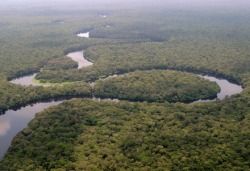
Tropical Rainforests
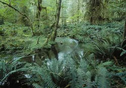
Africa has the world's second-largest area of rainforests. The largest is in the Congo River basin.
Located along the central coast of Africa.
Areas with hot and humid climates and dense forests.
Home to many animals and birds.
Home to small groups of people who live by gathering food from the forest or living on small subsistent farms. They live simple lives that have little impact on the environment.
Rapid population growth and the need for fuel is causing people to cut down trees faster than they can be replanted.
Today commercial logging is creating deforestation and destruction of the rainforests.
Kalahari Desert
Africa's other great desert.
Located in the southern part of Africa.
Surrounded by semi-arid areas that are also becoming drier.
Located in the southern part of Africa.
Surrounded by semi-arid areas that are also becoming drier.
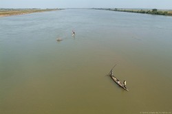
Nile River
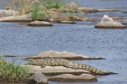
The longest river in the world.
It flows northward over 4,000 miles until it reaches the Mediterranean Sea.
Two of its tributaries are the White Nile and Blue Nile.
The White Nile, the longest tributary of the Nile River, begins in Lake Victoria.
Lake Victoria is the largest lake in Africa.
It flows northward over 4,000 miles until it reaches the Mediterranean Sea.
Two of its tributaries are the White Nile and Blue Nile.
The White Nile, the longest tributary of the Nile River, begins in Lake Victoria.
Lake Victoria is the largest lake in Africa.
Congo River
Flows through central and west Africa, through the largest rainforest in Africa.
Begins in central Africa near Lake Tanganyika and flows almost 3,000 miles before it reaches the Atlantic Ocean.
Lake Tananyika is one of the largest freshwater lakes in the world. It is also one of the deepest.
Begins in central Africa near Lake Tanganyika and flows almost 3,000 miles before it reaches the Atlantic Ocean.
Lake Tananyika is one of the largest freshwater lakes in the world. It is also one of the deepest.
Niger River
The third largest river in Africa.
Flows from Guinea over 2,600 miles to the African coast.
Its mouth is a delta, sometimes called the "Oil Delta," because the oil industry is centered there.
Flows from Guinea over 2,600 miles to the African coast.
Its mouth is a delta, sometimes called the "Oil Delta," because the oil industry is centered there.
Standard: SS7G1 The student will locate selected features in Africa.
